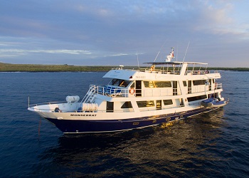
Alya Itinerary B - 6 days
ITINERARY B - 6 DAYS
MONDAY
AM: Baltra Arrival and Transfer to the boat
PM: Santa Cruz: Highlands (HK)
TUESDAY
AM: Isabela: Moreno Point (HK/SN/PR)
PM: Isabela: Elizabeth Bay (PR/PB/KY)
WEDNESDAY
AM: Isabela: Urbina Bay (HK/SN)
PM: Fernandina: Espinoza Point (HK/SN/PR)
THURSDAY
AM: Isabela: Tagus Cove (HK/SN/PR/PB/KY)
PM: Isabela: Vicente Roca Point (PR/SN)
FRIDAY
AM: Santiago: Espumilla Beach (HK)
PM: Santiago: Egas Port (HK/SN)
SATURDAY
AM: Santa Cruz: Bachas Beach (HK)
Baltra: Transfer to the Airport
HK: HIKE / SN: SNORKEL / PR: PANGA RIDE / KY: KAYAK /
PB: PADDLE BOARD
DAY 1: MONDAY
AM: BALTRA AIRPORT ARRIVAL AND TRANSFER TO THE BOAT.
Transfer in. Welcome on board Alya Catamaran.
PM: SANTA CRUZ: HIGLANDS
After lunch, we will visit HIGHLANDS OF SANTA CRUZ, where we will hike and encounter giant tortoises in their natural habitat, a natural wonder. For this visit, we recommend using sports shoes, long pants, a raincoat, a hat, and sunblock. Return to Alya. (-/L/D)
DAY 2: TUESDAY
AM: ISABELA: MORENO POINT
Is located on the north coast of Isabela Island between Sierra Negra and Cerro Azul Volcanoes. The main attractions at Punta Moreno are coastal lagoons amid black lava flows where there are several species of birds. It has a panoramic view of the three most active volcanoes in the Galapagos: The Sierra Negra, the Cerro Azul (Isabela Island), and La Cumbre (Fernandina Island). Lunch.
PM: EISABELA: LIZABETH BAY
This is one of the island’s breeding sites for penguins. Located on the west coast of Isabela, Elizabeth Point is a marine visitor site. Visit Red Mangrove Cove: Brown pelicans, flightless cormorants, spotted eagle rays, golden rays, and sea lions are often seen. Dinner. (B/L/D)
DAY 3: WEDNESDAY
AM: ISABELA: URBINA BAY
this place is located at the base of Alcedo Volcano between Elizabeth Bay and Tagus Cove. Wet landing.
The trail length is around 3.20 Km; during this, we can observe land iguanas, hawks, and tortoises. It is also possible to see red and blue lobsters. Lunch.
PM: FERNANDINA: ESPINOZA POINT
Fernandina is the third biggest island in the Galapagos and has only one visiting site: Espinoza Point, famous marine iguanas for the large colonies of marine iguanas and the home of the flightless cormorant, the Galapagos penguin, snakes, and more.
From Espinoza Point, we can admire the beauty of Fernandina Island and its volcano which last erupted in May of 2005.
Fernandina is the only island that doesn’t have mammals and the open areas are extremely fragile.
From January to June, the nesting period of the marine iguana, we take great care when walking. Dinner. (B/L
DAY 4: THURSDAY
AM: ISABELA: TAGUS COVE
It is located to the west of Darwin Volcano on Isabela Island. While walking, we will find several inscriptions (names of pirates) dating back to the 1800s. From here, we can see Darwin Lake, a saltwater lake with a depth of approximately 9 m. It contains no fish. It is very common to see a variety of bird species. Lunch.
PM: ISABELA:VICENTE ROCA POINT
Is comprised of two separate coves, this site is a large bay with spectacular sea life. Keep an eye out for seahorses, sea turtles, and the strange yet fascinating Mola-mola (sunfish). Dinner. (B/L/D)
DAY 5: FRIDAY
AM: SANTIAGO: ESPUMILLA BEACH
The main attractions include Palo Santo Wood, the beach, and the stunning landscape; the beach is a very important site for tortoises because they use this place for nesting. Lunch.
PM: SANTIAGO: EGAS PORT
Here we find a beautiful black sand beach; to the south of the beach is the Pan de Azucar Volcano, whose volcanic deposits have contributed to the formation of the black sand beach. The crater of this volcano contains a saltwater lake that dries up during hot weather. Between 1928 and 1930, explorations to develop a salt mine were carried out, but it was decided that a mine was not feasible. The workers’ use of endemic woods also damaged the environment and the development was scrapped. Descent to the salt mine is not allowed. Dinner. (B/L/D)
DAY 6: SATURDAY
AM: SANTA CRUZ: BACHAS BEACH
This beautiful beach is located north of Santa Cruz Island; the beach is one km long. The site was named during WWII (World War II) when the American army left two barges on the beach. The early colonists couldn’t pronounce barges correctly, so they called the area “Bachas”. Transfer out. (B/-/-)
** This itinerary is subject to change without notice; due to seasonal changes, weather conditions, or Galapagos National Park regulations. **


